Satya's blog - Returning from W North Carolina
I guess I should wrap this up, it's been dragging on too long.
The April 2005 trip ended on April 18th, 2005.
We woke up, finished off the food we had, and checked out.
Instead of hitting I-26 early
and heading back the fast way,
I decided to take the back roads.
That would have taken 5 hours tops.
The way we finally did it, we started around 0900L and got home around 2000L.
First we went from Cherokee back to Dillsboro. Didn't stop, and got into Sylva almost immediately -- the border is a few hundred feet from the Dillsboro train station on Depot Street. I have a map of the area, go see the pictures. AT Sylva, we stopped at the visitor's center, looked (from afar) at the famous courthouse, and then walked around downtown a bit. This was about 1030L, I remmeber because every breakfast place had already closed or would open at 1100. On a Monday. Anyway, the nice lady at the visitor's center had told us about a breakfast place called... I can't remember. A diner, anyway. I think it was calle dthe Coffee Shop... yes, that's it and it's on Main(?) Street. Very nice sandwiches -- well we were hungry -- nice service (and I'm not saying that just because one of the waitresses was, maybe, a former Miss NC or something), family-owned, I think. Nice dessert. I endorse this product and/or service. From Sylva we took of and headed down the 107. That's where the adventure began: The plan was to head down 107 to Tuckasegee, split off to the 281 as far as the 64 at Lake Toxaway, head east on 64, and join the 178 to Orangeburg and then the 26 or 78 to Charleston. See map: 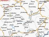
The 281 is unpaved for about 20 miles. Now that was fun. I stayed in neutral on the downslopes and braked a lot. Later I found that this is wrong -- I should downshift and the engine will hold speed for me. At least my brakes didn't wear out. Here's a picture: 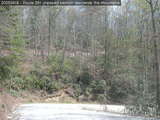
In the picture, you can see part of 281 above, which goes to the left and comes down behind the camera. It's pretty twisty, and keeps throwing pebbles into the underbody. Wish I had mudflaps. Couldn't get much above 20mph. Anyway, we hit the 178 eventually and then got stuck behind trucks for the next 300 miles. (Ate at a McDonald's in Greenwood. Almost took the wrong turn there, too, but saw signs at the last minute -- twice -- and got back on 178.) Besides, there were towns with a speed limit of 30 every 20 miles, a one-lane highway, and it got frustrating. So at Orangeburg (it was past 1800 now) we looked carefully at the DoT map, got on the 26, stopped at a rest stop (last one before Chas, which is why the DoT map was important -- I'd have got on at an "exit" after the rest-stop), then high-tailed it to Charleston. So ended. Last updated: Jan 22 2006 13:09 |
|