Satya's blog - westnorthcarolina/
I'm going to make a series of blog entries about our recent trip
to the mountains of Western North Carolina,
specifically
Cherokee, NC, the Cherokee nation,
and the Great Smoky Mountains National Park.
This is going to be a blog section under
http://www.thesatya.com/blog/westnorthcarolina/
and a web page accessible as
http://www.thesatya.com/blog/westnorthcarolina/indexr.html
The plan was to drive up to Dillsboro, NC on Saturday morning and ride the Great Smoky Mountains Railroad (tickets bought on phone on Friday), which starts at 1 p.m. and ends at about 5 p.m. Then head to the hotel (reserved online on Friday) at Cherokee, NC, maybe wander around Cherokee. Then on Sunday wander around Cherokee and the Great Smoky Mountains national park, then drive back on Monday. Last updated: Apr 19 2005 08:39
Round trip distance was 730 miles. About 310 miles to Dillsboro,
Another 340 miles or so back, or maybe 310, and the rest around Cherokee
and the Great Smoky Mountains --
about 70 miles.
Filled the gas tank at Calhoun/Meeting, and headed up Meeting to 26W. Er, the on-ramps have changed due to the new Cooper River bridge construction. The next 280-odd miles were spent on I26, passing Columbia and Spartanburg. Stopped about 3 times to rest. Cool temperatures. I pulled a lot of maps off Mapquest and looked at Google Maps as well, but Google maps are hard to download. The 26 goes north from Charleston and about 30 miles past the North Carolina border meets Interstate 40. We were supposed to get on 40 at exit 32B (left and west) and a couple of miles later get on 74 west (see map). But due to confusion over exit numbers we went much further on 40 and eventually exited at Canton (see map) onto 23. Proceeded to Dillsboro (just west of Sylva on the map, the Sylva town limit is just a few hundred feet from Dillsboro downtown) and caught the Great Smoky Mountain Railroad's 1pm Bryson City train about 15 minutes before boarding time. 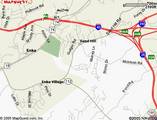
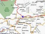
(Note the town of Enka, shown on both maps. Also note, the scales differ.) Last updated: Jan 22 2006 13:04
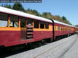
After parking (costs $3) in the GSMR parking lot on Depot St (off 107),
the first thing I saw was the train parked on a siding near the station.
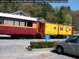
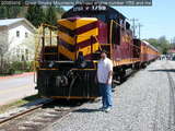
I guess they borrowed, bought, or leased the caboose from Chessie systems. It's fairly common to see engines from different railroads. I once saw a BNSF engine in South Carolina. BNSF is more a west-coast railroad. Since we had already bought tickets, we just picked up paper tickets based on the confirmation number and strolled around looking at the train. It consisted of a diesel engine, number 1755, followed by a generator car and a string of closed and open coaches. The Chessie caboose was on the following end. On the return trip, the engine was removed and placed at the other end. (We heard people speculating on the outbound trip that the engine would push the train back. In that case we would have been limited to 5 or 10mph.) That made the order: engine, caboose, cars, generator. 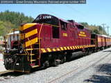
The next two pictures show the front of the engine. The first picture (all pictures are linked to the full-size version, click (or whatever) on it) shows the coupler, uncoupling ("cut"?) levers, ditch lights, brake hose, and MU hoses. The coupler is better seen in other pictures. The brake hose connects all the cars together to the compressed air system. This sets up air pressure in the brake cylinders and disengages the brakes. This means, if cars get uncoupled, the brakes lose air pressure from the broken hose and engage, causing the uncoupled cars to stop. The MU (multiple-unit) hoses are used to connect multiple engines together. The electrical and air pressure signals in these hoses allow a single operator to control the engines as one unit. Actually, I'm not sure which of these hoses are the brake hose. I thought it was the single big one. I used to know. 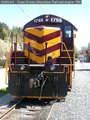
The next picture shows a coupling between cars. Not much to see, really. The set of 3 hoses, one on each side just like on the engine, is joined together. 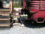
I tried to get a picture of one of the trucks. It's not very clear. Some cars had 3-axle trucks and some had 2-axle trucks. 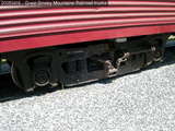
Last updated: Jan 22 2006 13:05
Continuing the account of Saturday April 16, I was embarked upon a
railway train in the general direction of the city of Bryson, NC,
when my astonished eyes came upon these sights.
Okay, Edgar Rice Burroughs I'm not. But here's a nice shot of th train pulling out of the station: 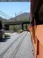
Scenes for the movie The Fugitive were shot here. Specifically, the ones where a train hits the Illinois correctional department's bus with Harrison Ford in it. 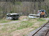
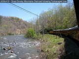
Here's a trestle bridge across the Tuckasegee River. After this, the track enters a tunnel and the open air cars go almost completely dark for about a minute. Can be scary. 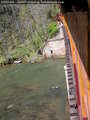
Two shots of the train on a curve near Whittier: 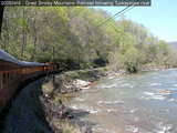
At Bryson City, a tanker and a caboose on a siding. This caboose is painted in Santa Fe railroad colors. 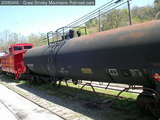
Most of the route is boring, unless you like hill-and-river scenery. Riding the cab would have been more fun. The only bit of excitement was when we had to stop for the conductor to move trash bags off the track. Someone threw trash on the tracks. Why? Last updated: Jan 22 2006 13:01
In Bryson City, we first had a bit of lunch and
then I went to look at the famous
railroad museum
and Lionel pusher.
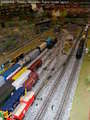
They gave me (and everyone else) a sheet of paper with about 20 scenes listed, which I had to search for on the layout. Things like "Dog" (it was about an inch high on the rather large layout... they dont' give the size on the site, bah) and "Man fishing" and "railfan photographing passing trains" (that was really hard to spot). A good way to get people to take a hard look at the details, which are easy to miss while taking in the big picture. I took 9 pictures but I'll show only a couple of them here: 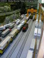
In the meantime the engine had been shunted and moved to the other end of the train. The return trip was so boring -- I can only stand so many miles of mountain and river -- that I dozed most of the way back. Then we went to Cherokee and the hotel. This was still Saturday April 16. Last updated: Jan 22 2006 13:06
This being hill country,
the roads had pretty steep grades -- 8% ins some places.
(A train can barely handle 4%.)
My Hyundai was grinding a bit, but made it up and down everything.
These were real roads, real paved highways, unlike the 281 that we took
on the way back... but that's for later.
We didn't do much else on Saturday, since most of the evening was spent looking for food. (We did not want the usual "fast" "food".) We eventually ate at the hotel -- a nice salad and chicken rolls.
Continuing the account of the North Carolina trip, Sunday April 17, 2005.
Woke up, ate some of the packed stuff, and drove into downtown Cherokee. It's a bunch of gift shops. Bought some stuff. I wanted to buy windchimes, but the wooden set I liked were all made in Indonesia. If I go somewhere, the souvenirs I buy should be made there, eh? Bought some coffee mug, fridge magnet type of stuff. The visitor's center was a gold mine: I found excellent DoT-type maps of North and South Carolina, which later saved my butt. There was a chairlift in the middle of downtown -- which is in the middle of hills. So we went up. A little scary at first, your legs hang over nothing but a river, a road, the hillside.... Anyway the view from the top was okay: 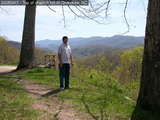
Coming down: 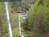
We wandered around for a while looking for authentic Native American food, didn't find any, tried for Chinese buffet, found it closed, and ate at Big Boy where we got the most expensive per ounce burgers in the world. At least McDonald's lived up to expectations. Lots of places were closed. Sigh. Last updated: Jan 22 2006 13:08
Continuing the account of the North Carolina trip, Sunday April 17, 2005.
After wandering around Cherokee, we eventually drove into the national forest. A helpful park ranger at the Oconaluftee visitor center told us about Clingman's Dome, which is supposed to be some 40 feet below the highest point east of the Mississippi -- presumably west of the east US coast, too. He also told us about some nice trail, but we missed it. The drive through the forest/park is nice -- along the Oconaluftee river (see map). Nice twisty roads. We went up the Blue Ridge Parkway for a few hundred meters, but decided we didn't want to go to Asheville just then. Clingman's Dome parking lot is reached by turning off the park road just before it crosses the Appalachian trail. Another steeper and twistier road goes up to the parking lot, from where it's a hard half-mile 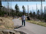
At the top is a spiral walkway that leads up higher to an observation post. This walkway is a little scary if you are at all afraid of heights, but the view from the top is nice. ("I'm at the top of the world, looking down Clingman's Dome, and I have vertigo.") 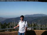
Walked back down, which is also hard because it hurt my shins. Just have to be careful and take it slow. Carrying a stick or hiking staff probably helps. We went to see the famous Appalachian trail at Newfoundland Gap (see map). Apparently it's also the Tennessee/North Carolina border: 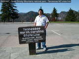
The same park ranger told us about Mingo Falls, which is either 150 or 400 feet -- probably 150. We got a little confused on the way, wandering into KOA campground where the nice people told us it's about 20 minutes up the road. I think they meant 20 minutes on foot, because it was around the next bend. Here, poor out-of-shape me climbed a huge series of steps along the waterfall to the top, where I found a bridge across the falls. Nice setting, nice water. I wandered into the stream a bit: 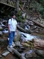
And then we headed back to Cherokee. Last updated: Jan 22 2006 13:08
I guess I should wrap this up, it's been dragging on too long.
The April 2005 trip ended on April 18th, 2005.
We woke up, finished off the food we had, and checked out.
Instead of hitting I-26 early
and heading back the fast way,
I decided to take the back roads.
That would have taken 5 hours tops.
The way we finally did it, we started around 0900L and got home around 2000L.
First we went from Cherokee back to Dillsboro. Didn't stop, and got into Sylva almost immediately -- the border is a few hundred feet from the Dillsboro train station on Depot Street. I have a map of the area, go see the pictures. AT Sylva, we stopped at the visitor's center, looked (from afar) at the famous courthouse, and then walked around downtown a bit. This was about 1030L, I remmeber because every breakfast place had already closed or would open at 1100. On a Monday. Anyway, the nice lady at the visitor's center had told us about a breakfast place called... I can't remember. A diner, anyway. I think it was calle dthe Coffee Shop... yes, that's it and it's on Main(?) Street. Very nice sandwiches -- well we were hungry -- nice service (and I'm not saying that just because one of the waitresses was, maybe, a former Miss NC or something), family-owned, I think. Nice dessert. I endorse this product and/or service. From Sylva we took of and headed down the 107. That's where the adventure began: The plan was to head down 107 to Tuckasegee, split off to the 281 as far as the 64 at Lake Toxaway, head east on 64, and join the 178 to Orangeburg and then the 26 or 78 to Charleston. See map: 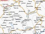
The 281 is unpaved for about 20 miles. Now that was fun. I stayed in neutral on the downslopes and braked a lot. Later I found that this is wrong -- I should downshift and the engine will hold speed for me. At least my brakes didn't wear out. Here's a picture: 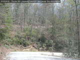
In the picture, you can see part of 281 above, which goes to the left and comes down behind the camera. It's pretty twisty, and keeps throwing pebbles into the underbody. Wish I had mudflaps. Couldn't get much above 20mph. Anyway, we hit the 178 eventually and then got stuck behind trucks for the next 300 miles. (Ate at a McDonald's in Greenwood. Almost took the wrong turn there, too, but saw signs at the last minute -- twice -- and got back on 178.) Besides, there were towns with a speed limit of 30 every 20 miles, a one-lane highway, and it got frustrating. So at Orangeburg (it was past 1800 now) we looked carefully at the DoT map, got on the 26, stopped at a rest stop (last one before Chas, which is why the DoT map was important -- I'd have got on at an "exit" after the rest-stop), then high-tailed it to Charleston. So ended. Last updated: Jan 22 2006 13:09 |
|